News
Hurricane Dorian 09/05/2019 - 1230 PM Update
Governor Brian Kemp has lifted the mandatory evacuation order for the coastal counties of Georgia.
All Chatham County residents can return to their homes at this time.
CEMA will be working throughout the day to return those who evacuated to an inland shelter through the Evacuation Assembly Area.
In coordination with the State of Georgia and Department of Public Health, efforts to return our Functional Access and Medical Needs population are underway and planning efforts to return them to their homes will begin tomorrow.
Soldiers, civilians, and family members of Hunter Army Airfield (HAAF) are to follow the guidance of the Fort Stewart/Hunter Army Airfield senior command.
The Talmadge Memorial Bridge has been inspected and is now open.
Chatham County will host a press conference live on Facebook at 1:00 PM on Thursday, September 5, 2019.
The City of Savannah and Town of Thunderbolt have discontinued their curfews.
Returning residents should be aware of the potential of power outages, downed powerlines, and debris in roadways. At this time the Georgia Power Outage Map indicated that approximately 6,000 residents in Chatham County are without power. Tybee and Skidaway Islands have been significantly affected by the power outages.
After the Storm Safety Tips from Georgia Power:
- Watch for downed wires. Downed power lines may be hidden by debris or fallen trees.
- Never touch any downed wire or attempt to remove tree branches from power lines – it can kill.
- Don't step in standing water or saturated ground where downed lines may be present. They could be electrified.
- Avoid chain link fences. They may be electrified by a downed line out of sight and conduct electricity over great distances.
- Watch for Georgia Power crews working across the state. If driving, move over one lane for utility vehicles stopped on the side of the road – it's the law in Georgia.
Protect electronics and appliances. Disconnect or turn off any appliances that will start automatically when power returns to avoid overloading circuits when power is restored.
El Gobernador Brian Kemp levantó la orden de evacuación obligatoria para todos los condados de Georgia.
Todos los residentes de Chatham pueden volver a sus residencias en este momento.
CEMA continuara trabajando todo el día para regresar a todos aquellos que evacuaron a un albergue tierra adentro desde el Centro de Reunión de Evacuación (EAA). En coordinación con el estado de Georgia y el Departamento de Salud Publica, los esfuerzos enfocados hacia aquellos que tienen problemas de movilización y/o necesidades medicas están en marcha. El regreso a sus viviendas comenzara mañana.
Militares, civiles, y los familiares de Hunter Army Airfield deben seguir las instrucciones emanadas del comando de Fort Stewart/ Hunter Airfield.
El puente Talmadge fue inspeccionado y ya esta abierto.
El Condado de Chatham ofrecera una conferencia en vivo hoy a la 1:00 pm a traves de facebook.
La Ciudad de Savannah y el suburbio de Thunderbolt han suspendido el toque de queda.
Las personas que regresan a sus hogares hoy deben estar informados de fallas en el servicio eléctrico, tendidos eléctricos caídos, y escombros en las vías. A esta hora según el mapa de Fallas del Servicio Eléctrico de Georgia Power, aproximadamente 6,000 residentes del condado Chatham están sin electricidad. Tybee y Skidaway Island han sido los mas afectados.
Consejos de el Servicio Eléctrico Georgia Power para después de la tormenta:
- Este atento a cables caidos. Algunos cables pueden estar escondidos debajo o dentro de los escombros o vegetación caída.
- Nunca toque un cable caído o trate de quitar los escombros o vegetación. Puede matarlo (a).
- No se pare en charcos o lagunas, o cuando el terreno este saturado de agua donde pueda haber cables del tendido eléctrico caidos. El terreno puede estar electrificado.
- No se acerque a cercas de metal. Pueden estar electrificadas por algún cable caído y transmitir la corriente por largos trechos.
- Este pendiente de los equipos del Servico Electrico Georgia Power, trabajando a lo largo del estado de Georgia. Si usted esta manejando un vehículo, muévase un canal mas allá para darle el espacio a los camiones de reparación. Es la ley en Georgia.
Proteja sus equipos electrónicos y sus accesorios eléctricos. Desconecte aquellos que comiencen a funcionar automáticamente una vez regrese el servicio eléctrico para evitar sobrecargar los circuitos.
Hurricane Dorian 09/05/2019 - 1030 AM Update
Governor Brian Kemp has lifted the mandatory evacuation order for the coastal counties of Georgia.
All Chatham County residents can return to their homes at this time.
CEMA will be working throughout the day to return those who evacuated to an inland shelter through the Evacuation Assembly Area.
In coordination with the State of Georgia and Department of Public Health, efforts to return our Functional Access and Medical Needs population are underway and planning efforts to return them to their homes will begin tomorrow.
Soldiers, civilians, and family members of Hunter Army Airfield (HAAF) are to follow the guidance of the Fort Stewart/Hunter Army Airfield senior command.
The Talmadge bridge is still currently closed. Georgia Department of Transportation will inspect the bridge today.
Returning residents should be aware of the potential of power outages, downed powerlines, and debris in roadways. At this time the Georgia Power Outage Map indicated that approximately 6,000 residents in Chatham County are without power. Tybee and Skidaway Islands have been significantly affected by the power outages.
After the Storm Safety Tips from Georgia Power:
- Watch for downed wires. Downed power lines may be hidden by debris or fallen trees.
- Never touch any downed wire or attempt to remove tree branches from power lines – it can kill.
- Don't step in standing water or saturated ground where downed lines may be present. They could be electrified.
- Avoid chain link fences. They may be electrified by a downed line out of sight and conduct electricity over great distances.
- Watch for Georgia Power crews working across the state. If driving, move over one lane for utility vehicles stopped on the side of the road – it's the law in Georgia.
Protect electronics and appliances. Disconnect or turn off any appliances that will start automatically when power returns to avoid overloading circuits when power is restored.
El Gobernador Brian Kemp levantó la orden de evacuación obligatoria para todos los condados de Georgia.
Todos los residentes de Chatham pueden volver a sus residencias en este momento. CEMA continuara trabajando todo el día para regresar a todos aquellos que evacuaron a un albergue tierra adentro desde el Centro de Reunión de Evacuación (EAA). En coordinación con el estado de Georgia y el Departamento de Salud Publica, los esfuerzos enfocados hacia aquellos que tienen problemas de movilización y/o necesidades medicas están en marcha. El regreso a sus viviendas comenzara mañana.
Militares, civiles, y los familiares de Hunter Army Airfield deben seguir las instrucciones emanadas del comando de Fort Stewart/ Hunter Airfield.
El puente Talmadge continúa cerrado. El Departamento de Transporte inspeccionara el puente hoy.
Las personas que regresan a sus hogares hoy deben estar informados de fallas en el servicio eléctrico, tendidos eléctricos caídos, y escombros en las vías. A esta hora según el mapa de Fallas del Servicio Eléctrico de Georgia Power, aproximadamente 6,000 residentes del condado Chatham están sin electricidad. Tybee y Skidaway Island han sido los mas afectados.
Consejos de el Servicio Eléctrico Georgia Power para después de la tormenta:
- Este atento a cables caidos. Algunos cables pueden estar escondidos debajo o dentro de los escombros o vegetación caída.
- Nunca toque un cable caído o trate de quitar los escombros o vegetación. Puede matarlo (a).
- No se pare en charcos o lagunas, o cuando el terreno este saturado de agua donde pueda haber cables del tendido eléctrico caidos. El terreno puede estar electrificado.
- No se acerque a cercas de metal. Pueden estar electrificadas por algún cable caído y transmitir la corriente por largos trechos.
- Este pendiente de los equipos del Servico Electrico Georgia Power, trabajando a lo largo del estado de Georgia. Si usted esta manejando un vehículo, muévase un canal mas allá para darle el espacio a los camiones de reparación. Es la ley en Georgia.
Proteja sus equipos electrónicos y sus accesorios eléctricos. Desconecte aquellos que comiencen a funcionar automáticamente una vez regrese el servicio eléctrico para evitar sobrecargar los circuitos.
Hurricane Dorian 09/05/2019 - 5 AM Update
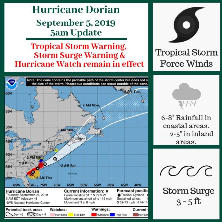
The center of Dorian will continue to move close to the coast of South Carolina through the day, and then move near or over the coast of North Carolina tonight and Friday. Tropical-storm-force winds extend outward up to 195 miles from the center.
Hurricane Dorian 09/04/2019 - 11 PM Update
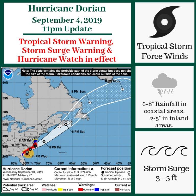
Maximum sustained winds are now near 115 mph with higher gusts. Dorian is a category 3 hurricane. Some fluctuations in intensity are expected during the next 12 hours, followed by slow weakening Thursday through Friday.
Hurricane Dorian 09/04/2019 - 8 PM Update
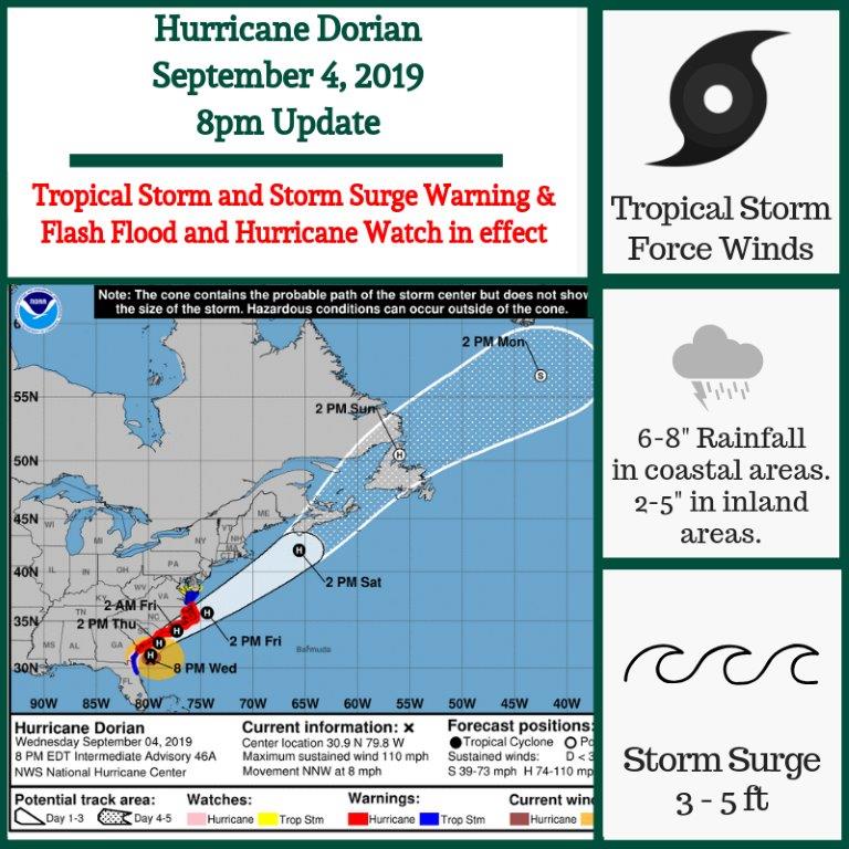
Reports from a NOAA Hurricane Hunter aircraft indicate that maximum sustained winds remain near 110 mph with higher gusts. Hurricane-force winds extend outward up to 70 miles from the center and tropical-storm-force winds extend outward up to 195 miles.
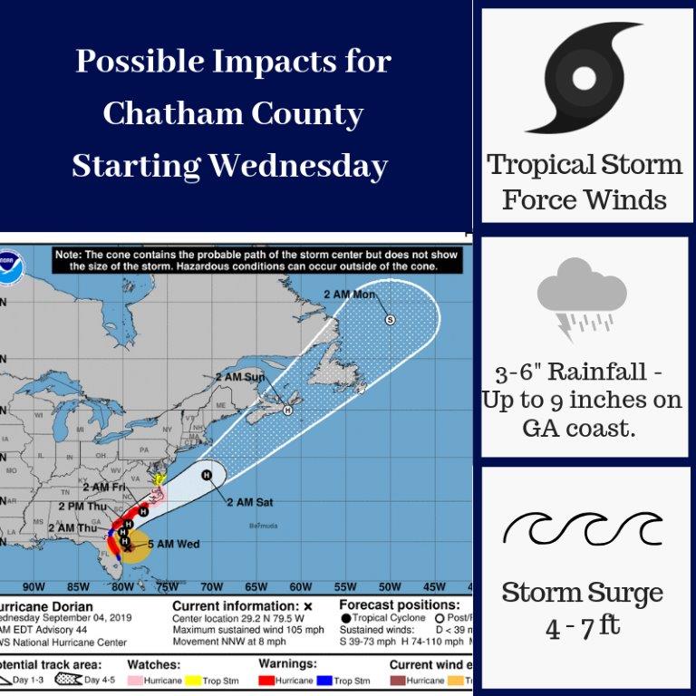
Hurricane Dorian 09/04/2019 - 5 PM Update
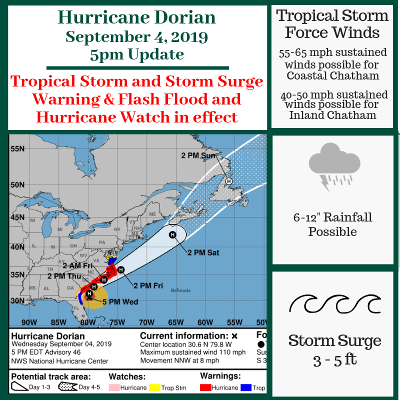
We are in a Tropical Storm and Storm Surge Warning, and a Flash Flood and Hurricane Watch. There is also a potential for dangerous rip currents as Dorian is making its way up the Georgia coast.
We are expecting 6-12 inches of rainfall, along with 3-5 feet of storm surge. The combination of rainfall and storm surge increases the risk for dangerous flash flooding in our area.
Currently we are expecting the eye of the storm to stay approximately 70 miles off the coast of Chatham. This means we are anticipating sustained Tropical Storm force winds to stretch across the county, and Hurricane Force winds to be approximately 20 miles off the coast as Dorian passes our area overnight.
Chatham is already experiencing sustained Tropical Force winds, as well as wind gusts near 70 mph. As a result of these winds, there are reports of downed powerlines across the county. Please stay away from any downed powerlines, treat them as they are live, and report the downed lines to Georgia Power.
The Talmadge Memorial Bridge remains closed.
If you have any questions about the storm, don’t hesitate to call us at 912-201-4500.
Continuamos bajo alerta de Tormenta Tropical y Marejada, así como aviso de inundaciones repentinas y de huracán. También existe alto riesgo de peligrosas resacas marítimas mientras Dorian sigue su curso a lo largo de la costa de Georgia.
Se esperan de 6 a 12 pulgadas de lluvia junto con 3 a 5 pies de marea. La combinación de lluvias y aumento de las mareas aumenta el riesgo de inundaciones en nuestra área.
En este momento se espera que el ojo del huracán se mantenga a aproximadamente 70 millas fuera de la costa del Condado Chatham. Eso significa que anticipamos vientos tropicales sostenidos a lo largo de todo el condado, y vientos huracanados a 20 millas de la costa cuando Dorian pase por nuestra área esta noche.
El Condado Chatham esta experimentando vientos de tormenta tropicale sostenidos, y ráfagas de hasta 70 millas por hora. Como resultado existen reportes sobre tendidos eléctricos caídos a lo largo del condado. Por favor MANTENGASE ALEJADO de cables de electricidad caídos, considérelos como cables de alta tensión y repórtelos a la Oficina de Electricidad de Georgia (Georgia Power).
El puente Talmadge esta cerrado.
Si tiene alguna pregunta sobre la tormenta o desea mas información no deje de comunicarse con nosotros al 912-201-4500
Hurricane Dorian 09/04/2019 - 11 AM Update
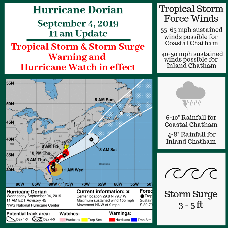
Chatham is in a Tropical Storm and Storm Surge Warning, and a Hurricane Watch. Dorian is expected to arrive in our area shortly bringing sustained Tropical Storm force winds which are anticipated to continue until 6 PM tomorrow (Thursday) night. These winds could cause structural damage and could also bring down powerlines leading to power outages.
We are also expecting to see coastal rainfall of 6-10 inches and inland rainfall of 4-8 inches in our area; additionally we are expecting storm surge of 3-5 feet. The combination of rainfall and storm surge increases the risk for dangerous flash flooding in our area.
Isolated brief tornadoes are possible, mainly along and east of I-95.
The Talmadge Memorial Bridge is closed.
If you have any questions about the storm, don’t hesitate to call us at 912-201-4500.
El condado Chatham se encuentra bajo alerta de Tormenta Tropical y Marejadas, así como aviso de huracán. Se espera que Dorian pase sobre nuestra área pronto trayendo consigo vientos de tormenta tropical sostenidos. Se pronostica que estos vientos continúen hasta las 6:00 PM de la noche de mañana jueves, lo cual pudiera causar danos estructurales a viviendas familiares y negocios, así como derribar postes del alumbrado produciendo la pérdida del servicio eléctrico.
También esperamos ver de 6 a 10 pulgadas de lluvia en la zona costera y de 4 a 6 pulgadas en el interior del condado. Asimismo, esperamos una marejada de 3 a 5 pies. La combinación de la lluvia y aumento en la marea aumenta el riesgo de peligrosas inundaciones repentinas en nuestra área.
Existe la posibilidad de tornados aislados, mayormente al este de la I-95.
El puente Talmadge esta cerrado.
Si tiene alguna pregunta sobre la tormenta o desea mas información no deje de comunicarse con nosotros al 912-201-4500
Hurricane Dorian 09/04/2019 - 8 AM Update
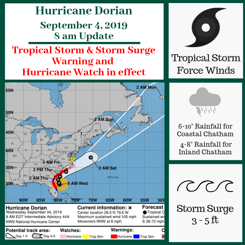
Chatham County is under a Tropical Storm and Storm Surge Warning, as well as a Hurricane Watch. The core of Dorian should pass along the Georgia coast today into tonight. Dorian is expected to remain a powerful hurricane during the next few days.
Tropical Storm force winds will begin late this morning and are anticipated to continue for a 24 hour period in Chatham County. Tropical Storm force winds could bring down powerlines leading to power outages and could produce some structural damage.
According to the National Weather Service - Charleston, we should expect to see coastal rainfall of 6-10 inches and inland rainfall of 4-8 inches in our area; storm surge is expected to be 3-5 feet. Torrential rain could be combined with storm surge could enhance the risk for dangerous flash flooding in our community.
Isolated brief tornadoes are possible, mainly along and east of I-95.
The Talmadge Memorial Bridge is closed.
If you have any questions about the storm, don’t hesitate to call us at 912-201-4500.
El condado Chatham se encuentra bajo alerta de Tormenta Tropical y Marejadas, así como aviso de huracán. El centro del huracán Dorian debe pasar sobre la costa de Georgia hoy hacia la noche. Se espera que Dorian mantenga su fuerza por los próximos días.
Los vientos de tormenta comenzaran mas tarde en la mañana de hoy y se pronostica que continúen por las próximas 24 horas en el condado de Chatham. Vientos de tormenta podrían producir la perdida del servicio eléctrico y algún daño estructural a casas y negocios.
De acuerdo con el Servicio Meteorológico Nacional (National Weather Servicio), en Charleston se esperan lluvias torrenciales en la zona costera de entre 4 a 8 pulgadas. La elevación de la marea puede ser de entre 3 a 5 pies. Las lluvias torrenciales y la elevación en la marea unidas pueden provocar inundaciones repentinas en nuestra comunidad.
Es posible que surjan tornados aislados, más probablemente a lo largo de la I-95.
El puente Talmadge esta cerrado.
Si tiene alguna pregunta sobre la tormenta o desea mas información no deje de comunicarse con nosotros al 912-201-4500
Hurricane Dorian 09/04/2019 - 5 AM Update
Dorian is moving NNW at 8 mph, and a northwest motion is expected through this morning.
Maximum sustained winds are near 105 mph with higher gusts.
Some weakening is expected during the next couple of days but is expected to remain a powerful hurricane.
Hurricane Dorian 09/03/2019 - 11 PM Update
Hurricane Dorian is now moving NNW at 6 MPH with maximum sustained winds of 110 miles per hour.
A turn toward the north is forecast by Wednesday evening, followed by a turn toward the north-northeast on Thursday morning.
Hurricane Dorian 09/03/2019 - 5 PM Update
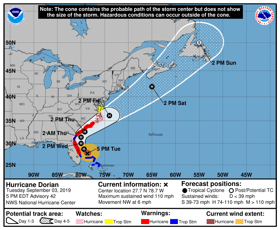
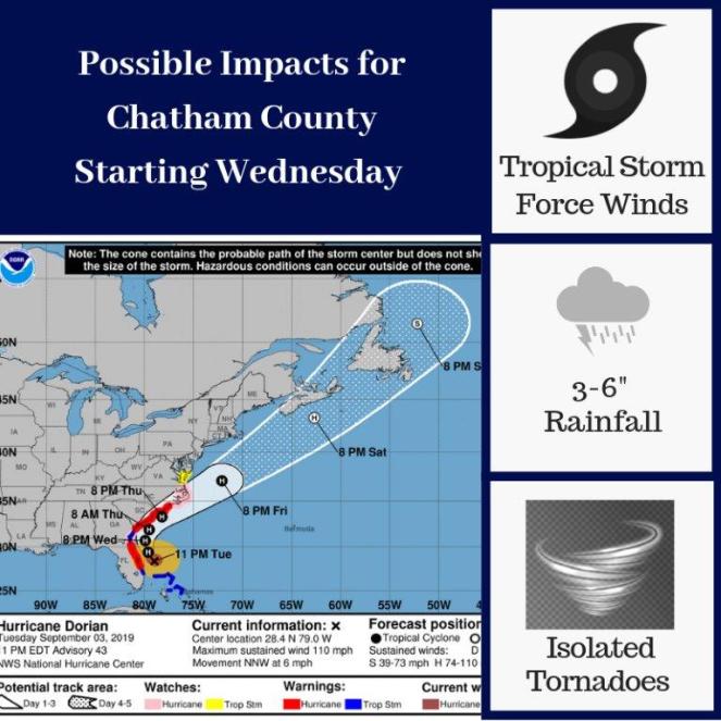
Chatham is under a Tropical Storm and Storm Surge Warning, and Hurricane Watch. Dorian is a category 2 storm and gaining speed - now moving at 6 miles per hour. Dorian has also become a larger hurricane and wind speeds have increased significantly.
Dorian is expected to remain a powerful hurricane over the next few days and it is anticipated to bring impacts to our area beginning Wednesday morning, including the potential for strong winds, heavy rains, and storm surge.
Chatham County is anticipated to experience tropical storm force winds for a 24 hour period beginning mid-day, Wednesday, September 4. Evacuation Zone A in Chatham County is expected to experience strong sustained tropical force winds of 50 miles per hour or higher.
The Mandatory Evacuation order remains in effect for Zones A and B. All residents, visitors and businesses in areas east of I-95 should be evacuating. The westerly contraflow on I-16 is in place and all four lanes of I-16 are flowing westerly towards Macon at this time.
The Evacuation Assembly Area (EAA) is closed and will not be open tomorrow.
The Talmadge Memorial Bridge will be closed beginning at 8 PM tonight (Tuesday).
The City of Savannah and Town of Thunderbolt have implemented a curfew beginning at 9 PM tonight, Tuesday, September 3, and ending at 6 AM on Wednesday, September 4. At this time, no curfews are in place for unincorporated Chatham County or any other jurisdictions within Chatham County.
The Savannah-Chatham County Public School System schools and facilities are closed through Friday, September 6.
If you have any questions about the storm, don’t hesitate to call us at 912-201-4500.
El Condado de Chatham se encuentra bajo un alerta de Tormenta Tropical y Aumento en el nivel de la marea por la tormenta. Igualmente se encuentra bajo un aviso de Huracan. Dorian es un huracan Categoría 2 que ha aumentado su velocidad y se esta moviendo a 6 millas por hora. Dorian también ha aumentado su tamaño y la velocidad de los vientos ha aumentado considerablemente.
Se espera que Dorian continue siendo un poderoso huracan a través de los días venideros. Se anticipa un impacto sobre nuestra área comenzando el miércoles en la mañana, incluyendo lluvias ttorrenciales fuertes vientos, y aumento en la marea.
El Condado de Chatham probablemente sentirá fuertes vientos tropicales por un periodo de 24 horas comenzando a mediados del miércoles, 4 de septiembre. Se espera que la Zona de Evacuacion A del condado de Chatham experimente fuertes vientos de tormenta tropical de hasta 50 millas por hora o mas.
La orden de Evacuacion Mandatoria se mantiene vigente para las Zonas A y B. Todos los residentes, visitantes, y negocios en el área este de la I-95 deben evacuar. El contrasentido hacia el oeste de la I-16 esta abierto y los cuatro canales de la I-16 se mantienen rumbo al oeste hacia Macon.
El Centro de Reunión de Evacuación (EAA) esta cerrado y no abrirá mañana.
El puente Talmadge Memorial cerrara esta noche (Martes) a las 8:00 PM
La Ciudad de Savannah y el area de Thunderbolt han implementado un toque de queda comenzando esta noche, martes 3 de septiembre a las 9:00 PM, hasta el miércoles 4 de septiembre a las 6:00 AM. Hasta el momento no hay toque de queda para la parte no-incorporada del condado de Chatham o cualquier otra jurisdicción.
Los colegios públicos del condado de Chatham y otros edificios escolares se encuentran cerrados hasta el viernes 6 de septiembre.
Si tiene alguna pregunta sobre la tormenta o desea mas información no deje de comunicarse con nosotros al 912-201-4500
CEMA Enters the Final Stage (Operating Condition 1) at 6 PM
CEMA advanced to OPCON 1 at 6 PM. This the final stage before potential impacts in the next 24 hours.
Residents are encourage to remain aware that Chatham County is under a Hurricane Watch, Tropical Storm Warning and Storm Surge Warning. This means the possibility exists for tornadoes, tropical storm force winds, and storm surge for the affected areas.
Tropical storm force winds could arrive as early as noon (12pm) tomorrow. Furthermore, storm surge of 4-7 feet above normally dry ground is likely. These are higher levels than experienced during Hurricane Matthew. It is likely that Highway 80 going to Tybee Island will be inundated with water during high tide periods.
Rain fail is expect to be 4-6 inches, however, could be as high 10 inches depending on the track of the storm.
All residents of Chatham County are strongly encouraged to finalize preparedness efforts.
Hurricane Dorian 09/03/2019 - 11 AM Update
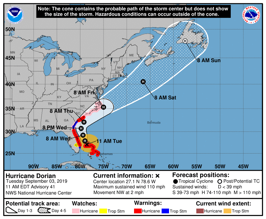
Chatham County is now under a Tropical Storm and Storm Surge Warning, as well as a Hurricane Watch. Dorian is now a category 2 storm, but is growing in size and slowly moving northwest.
Dorian is anticipated to begin impacting our area Wednesday morning and potential impacts include strong winds, heavy rains, and storm surge of 4-7 feet, with greatest impacts on the coast.
The Mandatory Evacuation order remains in effect for Zones A and B. All residents, visitors and businesses in Zones A and B should evacuate at this time. The westerly contraflow on I-16 is still in place and all four lanes of I-16 are flowing westerly towards Macon at this time.
The Evacuation Assembly Area (EAA) is currently open at the Savannah Civic Center and will close at 6 PM today, Tuesday, September 3. The EAA will not be open tomorrow.
The Talmadge Memorial Bridge will be closed beginning at 8 PM Tuesday night.
The City of Savannah has implemented a curfew beginning at 9 PM tonight, Tuesday, September 3, and ending at 6 AM on Wednesday, September 4.
The Chatham County Command Policy Group will be holding a press conference at 1 PM this afternoon, which will be live on our Facebook page @ChathamEMA.
If you have any questions about the storm, don’t hesitate to call us at 912-201-4500.
El condado de Chatham se encuentra ahora en estado de alerta de tormenta tropical y marejadas, asi como también estado de alerta de huracan. En estos momentos Dorian es un huracan Categoria 2, pero creciendo en tamano y moviéndose lentamente hacia el norte.
Se pronostica que Dorian afecte nuestra área el miércoles por la mañana, incluyendo lluvias torrenciales, fuertes vientos, y marea de 4 a 7 pies, particularmente en la zona costera.
La evacuación mandatoria se mantiene vigente para las zonas A y B. Todos los residentes, turistas, y oficinas o lugares de trabajo en las Zonas A y B deben evacuar ahora. El contraflujo de la I-16 con sentido Este-Oeste (hacia Macon) continua. Actualmente, TODOS los canales de la I-16 fluirán hacia el OESTE, vía Macon.
El Centro de Reunión de Evacuación (EAA) está abierto hasta las 6:00 PM HOY Martes, 3 de Septiembre, en el Centro Cívico de Savannah (Savannah Civic Center). El Centro no abrirá mañana.
El puente Talmadge Memorial cerrara esta noche (Martes) a las 8:00 PM
La Ciudad de Savannah ha impuesto un toque de queda comenzado a las 9:00 PM esta noche, martes 3 de septiembre, hasta las 6:00 AM del miércoles, 4 de septiembre.
El Grupo de Comando del Condado Chatham sostendrá una rueda de prensa en vivo a la 1:00 PM esta tarde a través de nuestra pagina de Facebook @ChathamEMA.
Si tiene alguna pregunta sobre la tormenta o desea mas información no deje de comunicarse con nosotros al 912-201-4500
Hurricane Dorian 09/03/2019 - 8 AM Update
Chatham County is now under a Storm Surge Warning and a Hurricane Watch. Hurricane Dorian is a slow moving storm, and is still located in the Bahamas. It is anticipated that it will remain off shore and continue moving to the North today.
Dorian’s impacts are expected in our area as soon as tomorrow (Wednesday) morning. The potential for strong winds with gusts up to 50 miles per hour is possible as soon as Wednesday morning. Additionally, Chatham could see 4-7 inches of rain as well as 4-7 feet of storm surge, with greater impacts on the coast.
The Mandatory Evacuation order remains in place for Zones A and B. All residents, visitors and businesses in Zones A and B should evacuate at this time. The westerly contraflow on I-16 begins at 8 AM today and all four lanes of I-16 will flow westerly towards Macon at that time.
The Evacuation Assembly Area (EAA) will be open at the Savannah Civic Center from 8 AM until 6 PM today (Tuesday) to transport citizens to inland shelters. People may take a Chatham Area Transit (CAT) bus to the Civic Center free of charge.
The Talmadge Memorial Bridge will be closed beginning at 8 PM tonight (Tuesday).
Passengers should contact their airlines directly regarding any questions about their flights.
Candler, St. Joseph’s, and Memorial Hospitals are sheltering in place and have canceled scheduled surgeries and out-patient procedures beginning today (Tuesday) through Thursday, September 5.
CEMA is still monitoring Hurricane Dorian and will provide regular updates to residents. For the most up to date information, be sure to visit our social media pages @ChathamEMA. If you have any questions about the storm, don’t hesitate to call us at 912-201-4500.
El Condado de Chatham se encuentra en estado de alerta respecto a marejadas y vientos huracanados. El huracan Dorian es una tormenta con desplazamiento lento y aun se encuentra sobre la Bahamas. Se pronostica que se mantenga fuera de las zonas costeras y continúe moviéndose hacia el norte en el dia de hoy.
Se espera que el impacto de los vientos de Dorian se sienta mañana (Miércoles) en la mañana. La probabilidad de fuertes vientos con ráfagas de hasta 50 millas por hora es posible tan pronto como Miércoles en la mañana. Asimismo, Chatham podría experimentar de 4 a 7 pies de mareas con impactos mas fuertes en la zona costera.
La evacuación mandatoria se mantiene vigente para las zonas A y B. Todos los residentes, turistas, y oficinas o lugares de trabajo en las Zonas A y B deben evacuar ahora. El contraflujo de la I-16 con sentido Este-Oeste (hacia Macon) comienza a las 8:00 AM hoy. TODOS los canales de la I-16 fluirán hacia el OESTE, via Macon, desde ese momento.
El Centro de Reunión de Evacuación (EAA) estará abierto desde las 8:00 AM hasta las 6:00 PM HOY Martes en el Centro Cívico de Savannah (Savannah Civic Center), para transportar al publico a los albergues (shelters) tierra adentro. Todo el publico puede utilizar el sistema publico de transporte (CAT) hacia en el Centro Cívico de manera gratuita.
El puente Talmadge Memorial (hacia las Carolinas) cerrara esta noche (Martes) a las 8:00 PM
Los pasajeros deben contactar a sus respectivas aerolíneas con respecto a todo lo referente a sus vuelos.
Los hospitales – Candler, St. Joseph’s y Memorial – continuaran albergando a sus pacientes en el sitio. Todas las cirugías y otros procedimientos externos han sido cancelados desde hoy (Martes) hasta el jueves, 5 de septiembre.
CEMA continúa monitoreando el huracán Dorian, y seguiremos informando a la comunidad de manera regular. Para la información más actualizada asegúrese de visitar nuestra página social @ChathamEMA. Si tiene alguna pregunta sobre la tormenta o desea información de como prepararse no deje de comunicarse con nosotros al 912-201-4500
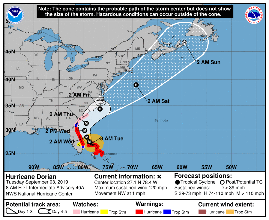
Hurricane Dorian 09/03/2019 - 5 AM Update
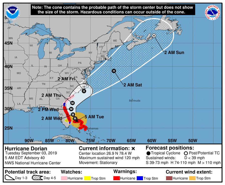
Chatham County is under a Hurricane Watch. This means the possibility exists for tornadoes and tropical storm force winds. Expected winds for Chatham County are 50-60 mph sustained and 70 mph gusts. Furthermore, this includes storm surge of 4-7 feet above high tide. These are higher levels than experienced during Hurricane Matthew.
-
Safety/Security
- Beach Access: As of September 1, 2019 Tybee Island began flying double red-flags indicating that water was closed to the public
- Curfew
- Savannah Police Department has enacted curfew beginning on Tuesday, September 3, 2019 from 9 PM to 6 AM daily until further notice
-
Food/Water/Shelter
-
Evacuation Assembly Area (EAA)
- Opening at 8 AM at the Savannah Civic Center on Tuesday, September 3, 2019
- Citizens will be transported to inland shelters and may travel with 2 pieces of luggage. Domesticated animals, in a crate and with shot records, will be accepted with their owners.
-
Schools: All Savannah Chatham County Public School System are closed through Friday, September 6th
-
Chatham County Courts are closed through Thursday, September 5, 2019
-
-
Health/Medical
- Savannah Animal Care located at West Bryant Street will be open 24/7 for pet emergencies during the storm
- Public Health Update:
- The emergency departments at St. Joseph Hospital on Mercy Blvd. and Memorial Health on Waters Ave. are open.
- 24/7 Urgent Care has several open locations
- Historic Savannah
- Midtown
- Pooler
- For more information, call (912) 234-CARE, LIKE their Facebook pages or visit UrgentCare247.com
-
Transportation
- Roads: 1-16 Contraflow begins at 8 AM on Tuesday, September 3, 2019
- Chatham Area Transit (CAT)
- CAT will provide free transportation to the Savannah Civic Center for residents without private transportation from 8 AM to 6 PM on Tuesday, September 3, 2019
- CAT suspended the Belles Ferry services at 8 PM on Monday, September 2, 2019
- The free downtown shuttle, CAT's paratransit service, and CAT Mobility will not operate Tuesday, September 3, 2019
- The customer service line, 912-233-5767, will operate on a shortened schedule from 6 AM until 6:30 PM Tuesday, September 3, 2019
- The ticket/informational window at the JMR International Transit Center on West Oglethorpe will also operate on a shortened schedule Tuesday, from 7 AM until Noon
- Bridge Closures:
- Talmadge Bridge will close starting at 8 PM, Tuesday, September 3, 2019
CEMA is still monitoring Hurricane Dorian and will provide regular updates to residents. For the most up to date information, be sure to visit our social media pages @ChathamEMA. If you have any questions about the storm, don't hesitate to call us at 912-201-4500.
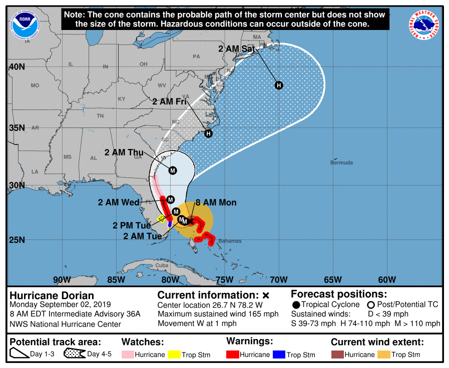
Hurricane Dorian 09/02/2019 - 11 PM Update
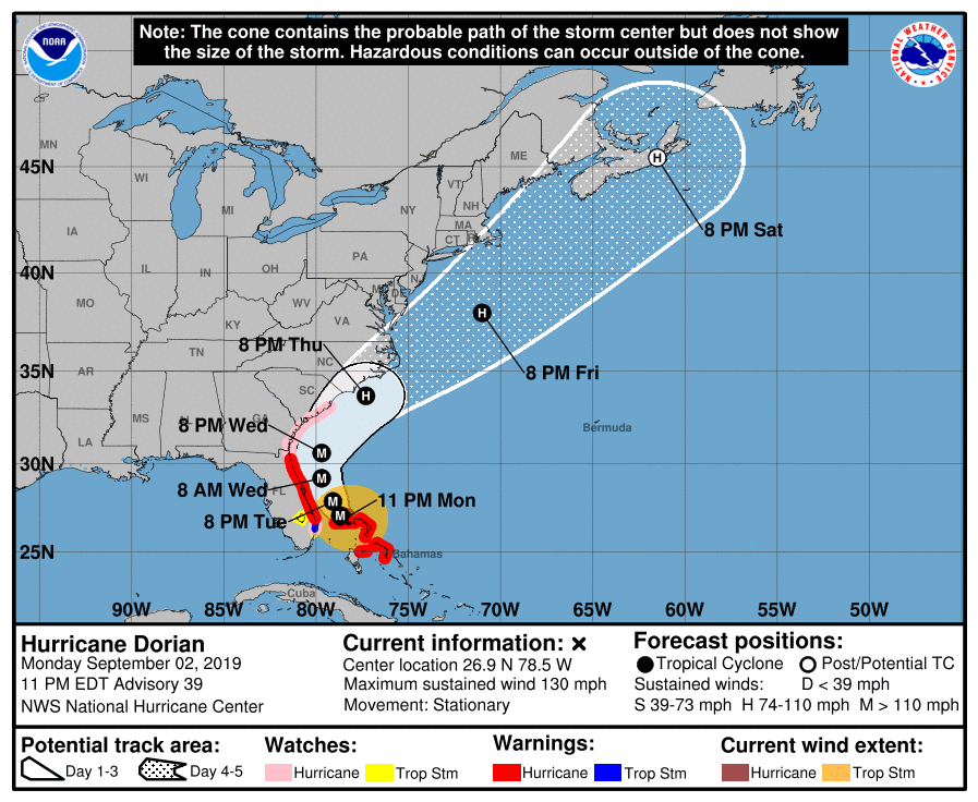
Chatham County is now under a Storm Surge Watch and a Hurricane Watch. Hurricane Dorian is still a stationary storm, which means that it has completely stopped moving forward. The storm is still located in the Bahamas and has not yet made the turn north.
The forecast track has remained consistent since this afternoon and impacts are expected as soon as Wednesday. The Mandatory Evacuation order remains in place for Zones A and B. All residents, visitors and businesses in Zones A and B should evacuate at this time.
The westerly contraflow on I-16 will begin at 8 AM tomorrow (Tuesday, September 3) and will allow all four lanes of I-16 to flow westerly towards Macon.
The Evacuation Assembly Area (EAA) will be open at the Savannah Civic Center at 8 on Tuesday, September 3 to transport citizens to inland shelters. People may take a Chatham Area Transit (CAT) bus to the Civic Center free of charge.
The Talmadge Memorial Bridge will be closed beginning at 8 PM on Tuesday, September 3.
Flights are operating as scheduled tonight, September 2. Passengers should contact their airlines directly regarding any questions about their flights.
Candler, St. Joseph’s, and Memorial Hospitals are sheltering in place and have canceled scheduled surgeries and out-patient procedures Tuesday, September 3 through Thursday, September 5.
There will be a curfew in place for the City of Savannah starting Tuesday, September 3 at 9 p.m. through Wednesday, September 4 at 6 a.m.
CEMA is still monitoring Hurricane Dorian and will provide regular updates to residents. For the most up to date information, be sure to visit our social media pages @ChathamEMA. If you have any questions about the storm, don’t hesitate to call us at 912-201-4500.
Hurricane Evacuation Zones
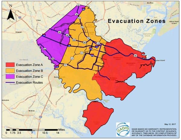
There is a mandatory evacuation for Zones A and B. Do you know your zone?
For an interactive map on the evacuation zones, please CLICK HERE
This will allow you to type in any address in Chatham County and easily identify which zone you are in.
Existe una orden de evacuación mandatoria para las Zonas A y B. Sabe usted en cual zona reside?
Este mapa interactivo le ayuda a identificar su zona. HAGA CLICK AQUÍ!
Este mapa le deja que usted escriba cualquier dirección en el condado Chatham y asi fácilmente identificar en que zona reside.
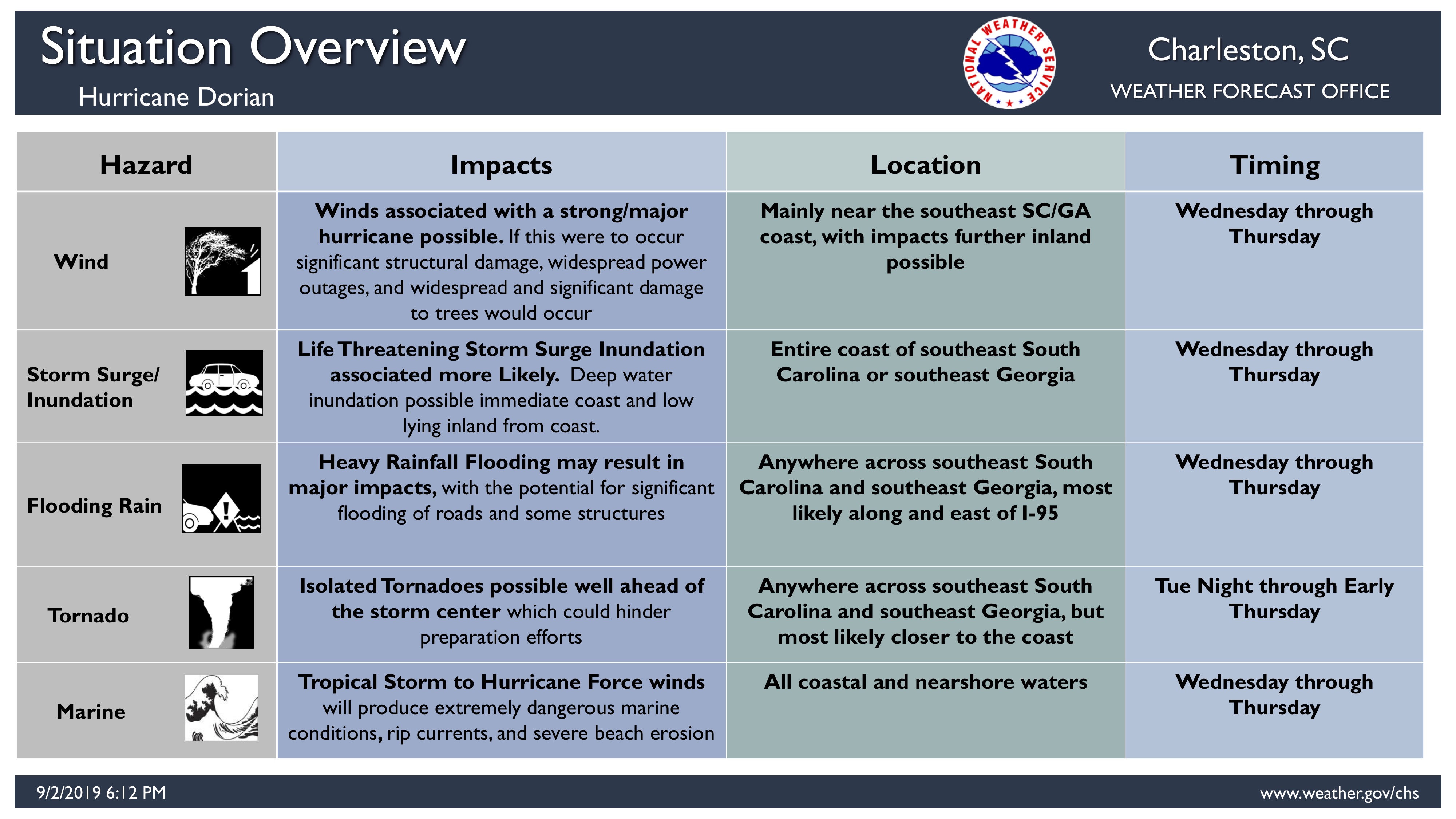
Threats from Hurricane Dorian
This infographic from the National Weather Service in Charleston helps identify imminent threats to our area from Hurricane Dorian. Stay safe. Stay informed.
Hurricane Dorian 09/02/2019 - 5 PM Update
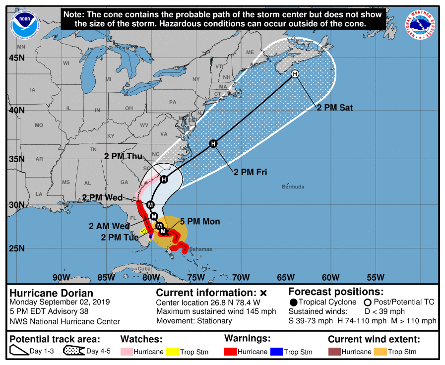
Chatham County is now under a Storm Surge Watch and a Hurricane Watch. Hurricane Dorian is now a stationary storm, which means that is has completely stopped moving forward. The storm is still located in the Bahamas and has not yet made the turn north.
The forecast track has remained consistent since this afternoon and impacts are expected as soon as Wednesday. The Mandatory Evacuation order remains in place for Zones A and B. All residents, visitors and businesses in Zones A and B should evacuate at this time.
The westerly contraflow on I-16 will begin at 8 AM tomorrow (Tuesday, September 3) and will allow all four lanes of I-16 to flow westerly towards Macon.
The Evacuation Assembly Area (EAA) will be open at the Savannah Civic Center from 8 AM until 6 PM on Tuesday, September 3 to transport citizens to inland shelters. People may take a Chatham Area Transit (CAT) bus to the Civic Center free of charge.
The Talmadge Memorial Bridge will be closed beginning at 8 PM on Tuesday, September 3.
Flights are operating as scheduled today, September 2, and tonight. Passengers should contact their airlines directly regarding any questions about their flights.
Candler, St. Joseph’s, and Memorial Hospitals are sheltering in place and have canceled scheduled surgeries and out-patient procedures Tuesday, September 3 through Thursday, September 5.
CEMA is still monitoring Hurricane Dorian and will provide regular updates to residents. For the most up to date information, be sure to visit our social media pages @ChathamEMA. If you have any questions about the storm, don’t hesitate to call us at 912-201-4500.
Hurricane Dorian 09/02/2019 - 11 AM Update
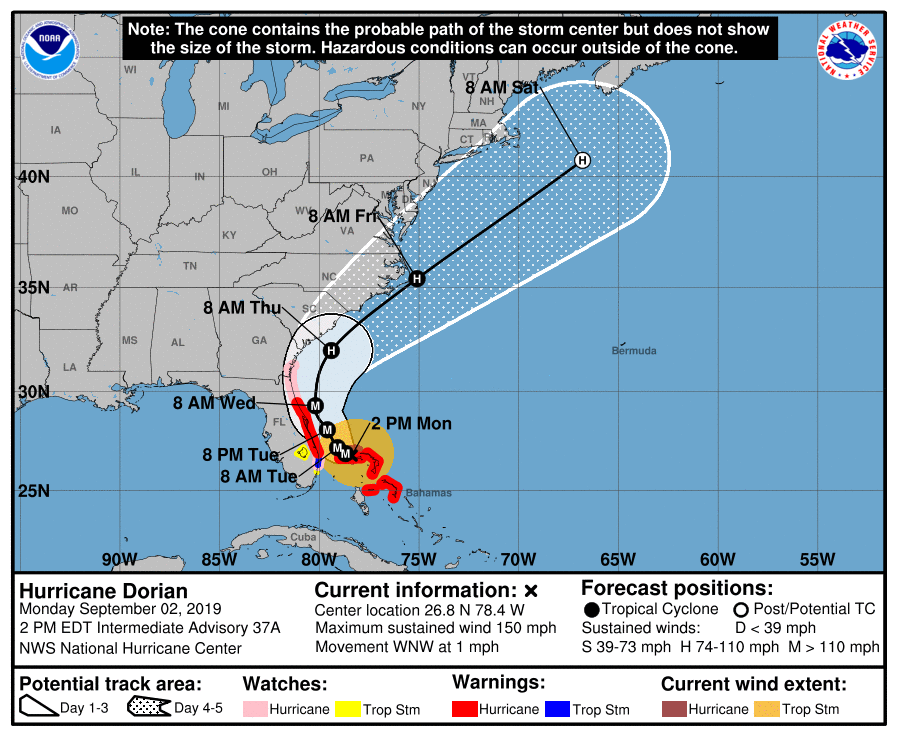
Dorian is still a major hurricane and is continuing to head west at 1 mile per hour. Chatham remains in the error cone mid to late this week with possible impacts in our area of strong winds, heavy rain, and flooding.
A mandatory evacuation order of all areas east of I-95 (Zones A and B) began today at noon, and residents should be finalizing their evacuation plans. The westerly contraflow on I-16 will begin at 8 AM tomorrow (Tuesday, September 3) and will allow all four lanes of I-16 to flow westerly towards Macon.
The Evacuation Assembly Area (EAA) will open at the Savannah Civic Center at 8 AM on Tuesday, September 3 to transport citizens to inland shelters. People may take a Chatham Area Transit (CAT) bus to the Civic Center free of charge.
CEMA will be going live from the Emergency Operations Center on our Facebook page today at 3:30 PM. Join us for the most up to date information and ask questions of CEMA staff.
CEMA is continuing to actively monitor Hurricane Dorian and will be providing regular updates to our residents. For the most up to date information, be sure to visit our social media pages @ChathamEMA. If you have any questions about the storm, don’t hesitate to call us at 912-201-4500.
Dorian continua siendo un huracan mayor desplazándose al oeste a 1 milla por hora. El condado de Chatham continua dentro del cono de error hasta mediados/finales de esta semana. El impacto a nuestra área incluye lluvias torrenciales, inundaciones costeras, y fuertes vientos. Se le recomienda a la comunidad preparase para estas eventualidades.
Una evacuación obligatoria de todos los residentes al este de la I-95 (Zonas A y B) comenzó hoy al mediodía, y los residentes deben estar por finalizar sus planes de evacuación. El cambio en la dirección de la I-16 comenzara a las 8:00 AM mañana (Martes, 3 de Septiembre), lo cual permitirá que los cuatro canales de la I-16 fluyan en sentido este-oeste hacia Macon.
El Centro de Evacuacion (EAA) abrirá en el Centro Civico de Savannah (Savannah Civic Center) a las 8:00 AM para trasladar a aquellos que necesiten ir a un albergue (shelter) tierra adentro. Los residentes podrán usar el sistema de transporte de Chatham hacia el Centro Civico (Civic Center) de manera gratuita.
CEMA informara en vivo en nuestra pagina de Facebook a las 3:30 PM. Sintonícenos para recibir la información mas actualizada.
CEMA continúa monitoreando el huracán Dorian, y seguiremos informando a la comunidad de manera regular. Para la información más actualizada asegúrese de visitar nuestra página social @ChathamEMA. Si tiene alguna pregunta sobre la tormenta o desea información de como prepararse no deje de comunicarse con nosotros al 912-201-4500
Hurricane Dorian 09/02/2019 - 8 AM Update
Dorian is still a category 5 hurricane and is continuing to head west. The storm’s speed has slowed again overnight and the storm is progressing at 1 mile per hour. Chatham remains in the error cone mid to late this week and residents should be prepared for possible impacts in our area such as heavy rains, flooding, and strong winds.
Residents should prepare by finalizing their Family Communications Plan; ensuring their emergency kit is stocked with non-perishable food, water, and hygiene items; and refilling prescription medications.
Residents are also encouraged to monitor local media outlets for current lists of school and business closures.
Join us this morning for the press conference at 10:30 AM, which will be live on our Facebook page.
CEMA continues to actively monitor Hurricane Dorian and will provide regular updates to our residents. For the most up to date information, be sure to visit our social media pages @ChathamEMA. If you have any questions about the storm, don’t hesitate to call us at 912-201-4500.
Dorian continúa siendo un huracán Categoría 5, desplazándose a 1 milla (2km/h) por hora hacia el oeste con vientos sostenidos de 165 millas (270 km/h) por hora. El condado de Chatham continua dentro del cono de error hasta mediados/finales de la semana que viene. El impacto a nuestra área incluye lluvias torrenciales, inundaciones costeras, y fuertes vientos. Se le recomienda a la comunidad preparase para estas eventualidades.
Los residentes del condado deben finalizar los preparativos para el huracán. Entre estos preparativos asegúrese de actualizar su plan de comunicación con sus familiares, equipar su equipo de emergencia con artículos de primeros auxilios, higiene general, comida no perecedera, y agua, así como también rellenar sus prescripciones medicas.
Se les recomienda a los residentes del condado chequear los canales de noticias locales para información actualizada sobre cierres de las escuelas y los sitios de trabajo. Acompáñenos esta mañana durante la conferencia a las 10:30 AM a través de nuestra pagina de Facebook.
CEMA continúa monitoreando el huracán Dorian, y seguiremos informando a la comunidad de manera regular. Para la información más actualizada asegúrese de visitar nuestra página social @ChathamEMA. Si tiene alguna pregunta sobre la tormenta o desea información de como prepararse no deje de comunicarse con nosotros al 912-201-4500
Hurricane Dorian 09/01/2019 - 5 PM Update
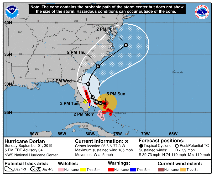
Dorian remains a major, category 5 hurricane. The speed of the storm has again slowed, it is heading west at 5 miles per hour and is currently 432 miles southeast of Chatham County. Chatham remains in the error cone of the storm mid to late this week. Possible impacts to our area include heavy rains, coastal flooding, and strong winds; residents are encouraged to prepare for these potential impacts.
Residents can prepare by refilling prescription medications to ensure you have enough to get through at least the next 7 days; clearing any debris which may have gathered in gutters or on roofs; and stocking emergency kits with items such as flashlights, non-perishable food, and water.
Residents are also encouraged to check local media outlets for up to date information regarding school or business closures.
CEMA is monitoring Hurricane Dorian and looks at each weather advisory to assess the potential impacts of the storm to our area. We will continue to provide regular updates to our residents. For the most up to date information, be sure to visit our social media pages @ChathamEMA. If you have any questions about the storm, don’t hesitate to call us at 912-201-4500.
Dorian continua siendo un poderoso huracán Categoría 5. La velocidad del huracán disminuyó nuevamente desplazándose hacia el oeste a 5 millas por hora. Dorian se encuentra actualmente a 432 del condado Chatham. El condado Chatham continua dentro del cono de error hasta mediados/finales de la semana que viene. El impacto a nuestra área incluye lluvias torrenciales, inundaciones costeras, y fuertes vientos. Se le recomienda a la comunidad preparase para estas eventualidades.
Los residentes del condado se pueden preparar rellenado sus prescripciones medicas para asegurarse que tengan suficientes medicinas por al menos 7 dias;
- Limpiando cualquier escombro que pueda tapar las canales o los techos;
- y llenado su equipo de emergencia con artículos de primeros auxilios, higiene general, comida no perecedera, y agua.
También se les recomienda a los residentes del condado chequear los canales de noticias locales para información actualizada sobre cierres de las escuelas y los sitios de trabajo.
CEMA continúa monitoreando el huracán Dorian, todos los avisos climatológicos, y analizando cualquier impacto potencial a nuestra área. Seguiremos informando a la comunidad de manera regular. Para la información más actualizada asegúrese de visitar nuestra página social @ChathamEMA. Si tiene alguna pregunta sobre la tormenta o desea información de como prepararse no deje de comunicarse con nosotros al 912-201-4500
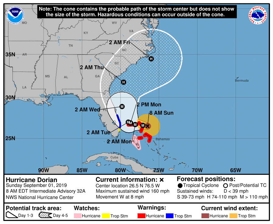
Hurricane Dorian 09/01/2019 - 11 AM Update
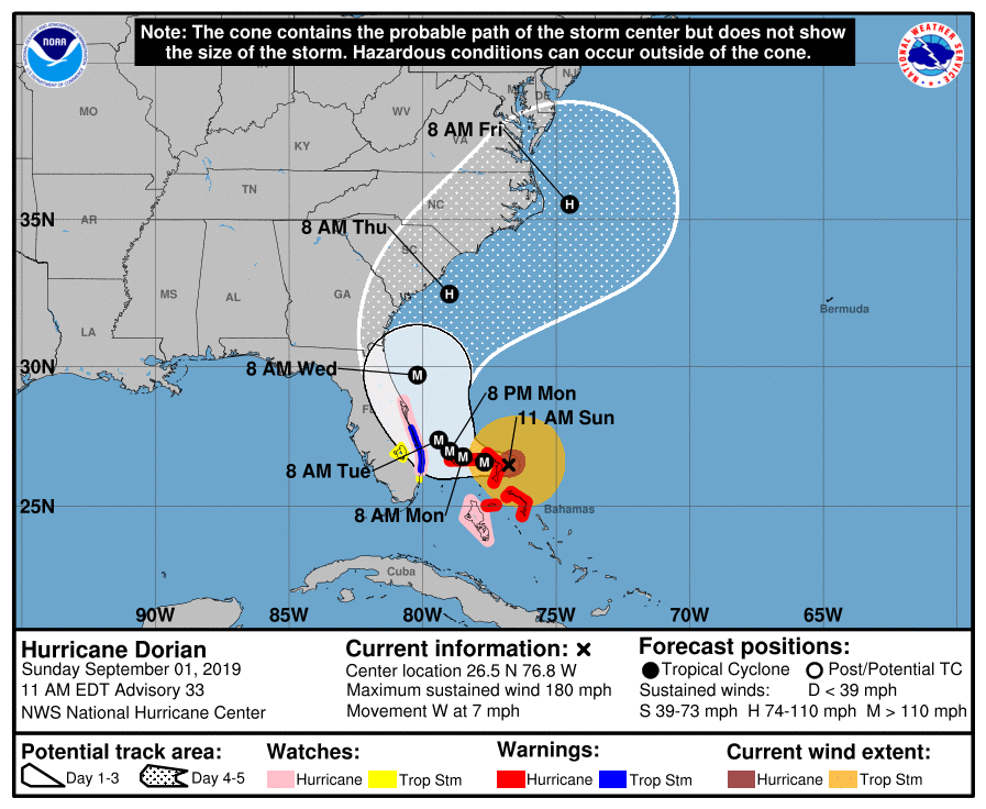
Dorian is still a major, category 5 hurricane. The speed of the storm has slowed again, it is heading west at 7 miles per hour and is currently 472 miles southeast of Chatham County. We remain in the error cone of the storm and could see potential impacts of strong winds, heavy rains, and coastal flooding in our area mid to late this week.
Residents should take time now to finalize their preparedness efforts. Some preparedness activities include updating your Family Communications Plan and ensuring your emergency kit is stocked with items such as first aid supplies, hygiene items, non-perishable food, and water.
CEMA is actively monitoring Hurricane Dorian and we will provide regular updates to residents. For the most up to date information, be sure to visit our social media pages @ChathamEMA. If you have any questions about the storm, don’t hesitate to call us at 912-201-4500.
Dorian continúa siendo un poderoso huracán Categoría 5. Dorian continua su trayectoria hacia el oeste, sin embargo, rebajó su velocidad de trayectoria a 7 millas por hora y se encuentra a 472 millas al sureste del condado de Chatham. Chatham todavía se encuentra dentro del cono de error y podría sufrir el impacto de fuertes vientos, torrenciales lluvias, e inundaciones de la parte costera a mediados de la semana que viene.
Una vez mas, este es el momento de finalizar los preparativos para el huracán. Entre estos preparativos asegúrese de actualizar su plan de comunicación con sus familiares, equipar su equipo de emergencia con artículos de primeros auxilios, higiene general, comida no perecedera, y agua.
CEMA continúa monitoreando la tormenta, y seguiremos informando a la comunidad de manera regular. Para la información más actualizada asegúrese de visitar nuestra página social @ChathamEMA. Si tiene alguna pregunta sobre la tormenta o desea información de como prepararse no deje de comunicarse con nosotros al 912-201-4500
Hurricane Dorian 09/01/2019 - 8 AM Update
Dorian is now a major, category 5 hurricane. It is heading west at 8 miles per hour and is currently 490 miles southeast of Chatham County. We remain in the storm’s error cone mid to late this week and could see direct impacts, such as heavy rain, strong winds and coastal flooding in our area.
All residents are encouraged to take time now to prepare for Dorian’s potential impacts to our area. Some preparedness tips include updating your emergency kits, securing any loose items outside your home or business, and gathering non-perishable food items.
CEMA is continuing to monitor Hurricane Dorian’s approach, the Emergency Operations Center is activated, and we will provide regular updates to residents. For the most up to date information, be sure to visit our social media pages @ChathamEMA. If you have any questions about the storm, don’t hesitate to call us at 912-201-4500.
Dorian se convirtió en un poderoso huracán Categoría 5, con fuertes vientos bordeando la Categoría 5. Dorian se dirige al oeste a 8 millas por hora y se encuentra a 490 millas al sureste del condado de Chatham. A pesar del cambio en la trayectoria al este, Chatham se encuentra aun en el cono de error para mediados de la semana que viene y podría recibir un impacto directo del huracán.
Enfáticamente les sugerimos a todos los que residen en el condado que se preparen para la eventualidad de un impacto directo. El riesgo y la amenaza de fuertes vientos, exceso de lluvia, e inundaciones continúan siendo una posibilidad cercana. Preparativos podrían incluir actualizar su kit de emergencia y planes familiares en caso de evacuación. Asegure cualquier objeto incluyendo muebles que estén sueltos afuera de su casa o lugar de trabajo. Para una lista mas detallada de los preparativos visite nuestra pagina de web www.chathamemergency.org.
CEMA continuara monitoreando la tormenta. El Centro de Operaciones de Emergencias ha sido activado, y continuaremos informando a la comunidad de manera regular. Para la información más actualizada asegúrese de visitar nuestra página social @ChathamEMA o nuestra página de web www.chathamemergency.org. Si tiene alguna pregunta sobre la tormenta o desea información de como prepararse no deje de comunicarse con nosotros al 912-201-4500
Hurricane Dorian 08/31/2019 - 5 PM Update
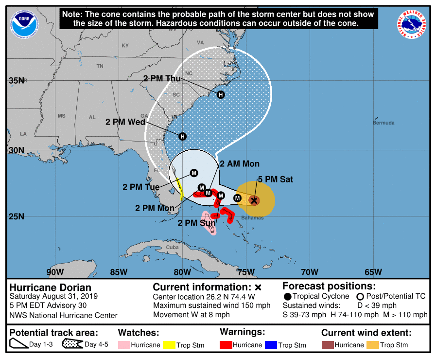
Dorian remains a major, category 4 hurricane and is still nearing category 5 strength. It is heading west at 8 miles per hour and is currently 562 miles southeast of Chatham County. Despite the track shift to the east, Chatham County remains in the storm’s error cone mid to late next week and we could see direct impacts in our area.
CEMA will advance to the Mobilization Phase at 6PM in preparation of Hurricane Dorian’s approach to the east coast of the United States. The Mobilization Phase allows Chatham County to start moving assets and putting them in place should they be needed.
Coordination of response efforts with local, regional, and state agencies continue. CEMA continues to work with the Command Policy Group (which is comprised of elected officials and County/Municipality leaders) and surrounding emergency management agency (EMA) directors to make decisions in the response to the storm.
Everyone should continue to finalize preparedness efforts. Some activities may include:
- Secure loose or lightweight items outside your house or business.
- Take a look at your Family Communications Plan. Determine how you would notify family and friends if communication networks were interrupted.
- Look around your home for any areas that could be affected by heavy rainfall. For example, take time to clear out your gutters and check for any debris gathering on your roof. Large amounts of debris left on your roof during a storm could cause your roof to weaken and leave you with a leak.
- Check your prescription medications to ensure you have enough to get you through at least the next 7 days. If not, request a re-fill from your pharmacist.
- Look in your pantry to determine what non-perishable food items you have available. If power were to go out, you want to make sure that you can still eat.
If you have any questions about the storm, don’t hesitate to call us at 912-201-4500.
Dorian continúa siendo un huracán mayor Categoría 4, con fuertes vientos bordeando la Categoría 5. Dorian se dirige al oeste a 8 millas por hora y se encuentra a 562 millas al sureste del condado de Chatham. A pesar del cambio en la trayectoria al este, Chatham se encuentra aun en el cono de error para mediados de la semana que viene y podría recibir un impacto directo del huracán.
El Centro de Emergencia de Chatham County comenzara la fase de movilización a partir de las 6 pm en preparación de la llegada del huracán a la costa este de los Estados Unidos. Durante esta fase Chatham County movilizara equipo y personal necesario en cualquier eventualidad.
La coordinación de los esfuerzos en respuesta al huracán con autoridades locales, regionales y estatales continua su curso. CEMA continúa trabajando con el Grupo de Comando de Políticas, el cual incluye individuos del Municipio y el condado, y personal de emergencia para aprobar cualquier decisión en respuesta a la tormenta.
Todo el mundo debería tomar este momento para finalizar lo referente a los preparativos para el huracán. Entre estos preparativos:
- Asegure cualquier objeto incluyendo muebles que estén sueltos afuera de su casa o lugar de trabajo.
- Revise su plan de comunicación con su familia en caso de que los sistemas de comunicación fallen.
- Chequee alrededor de su propiedad que las canaletas del techo estén limpias de hojas y desperdicios pues pueden debilitar el techo y crear goteras.
- Cheque sus prescripciones y asegúrese de rellenarlas si es necesario para que le duren por una semana.
- Revise su alacena para ver que comida no perecedera tiene o necesita. Si se va la electricidad es importante que puedan alimentarse.
Si tiene alguna pregunta sobre la tormenta o desea información de como prepararse no deje de comunicarse con nosotros al 912-201-4500
Hurricane Dorian 08/31/2019 - 11 AM Update
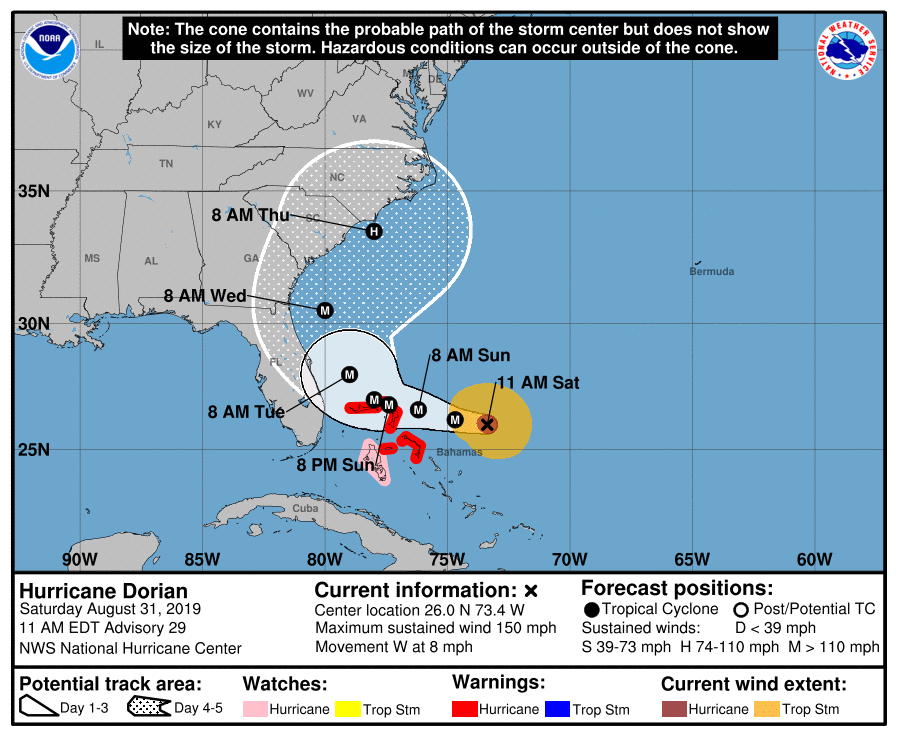
Dorian is still a major, category 4 hurricane, but is nearing category 5 strength. It is heading west at 8 miles per hour and is currently 650 miles southeast of Chatham County. The storm has slowed down significantly, as expected. Chatham County remains in the storm’s error cone mid to late next week and we could see direct impacts in our area.
We strongly encourage all residents to prepare for the storm’s impacts in our community. The threat of coastal flooding, heavy rain, and strong winds remain possibilities. Ways to prepare could include updating your family emergency plans and your emergency kit. For a list of suggested items to include in your emergency kit, visit www.chathamemergency.org.
CEMA is actively monitoring the storm and will be in the Emergency Operations Center this weekend. We will provide regular updates to residents as possible. For the most up to date information, be sure to visit our social media pages @ChathamEMA. If you have any questions about the storm, don’t hesitate to call us at 912-201-4500.
A estas horas Dorian continua siendo un fuerte Huracán Categoría 4, bordeando la Categoría 5. Dorian continúa moviéndose hacia el oeste a 8 millas por hora (13 km/h) y se encuentra a 650 millas millas al sur del condado de Chatham. El huracán desacelero su trayectoria como se esperaba. Chatham County aun se encuentra dentro del cono de error hasta mediados de la semana que viene, y existe la posibilidad de un impacto directo en nuestra área.
La trayectoria hacia el oeste debe continuar desacelerando hasta mediados de la semana que viene. De continuar esa trayectoria, Dorian debe estar bordeando la costa este de Florida en la madrugada del lunes hacia el martes.
Datos actualizados por el centro meteorológico indican que los vientos se han incrementado hasta llegar a 150 millas por hora (250 km/h). Vientos huracanados se extienden 30 millas (45 km) desde el centro del huracán, y fuertes vientos tropicales se extienden hasta 115 millas (185 km) desde el centro.
Enfáticamente les sugerimos a todos los que residen en el condado que se preparen para la eventualidad de un impacto directo. El riesgo y la amenaza de fuertes vientos, exceso de lluvia, e inundaciones continúan siendo una posibilidad cercana.
Preparativos podrían incluir actualizar su kit de emergencia y planes familiares en caso de evacuación. . Para una lista mas detallada de los preparativos visite nuestra pagina de web www.chathamemergency.org.
CEMA continuara monitoreando la tormenta durante todo el fin de semana y la semana que viene. Continuaremos actualizando la información según sea necesario. Para la información más actualizada asegúrese de visitar nuestra página social o nuestra página de web www.chathamemergency.org. Si tiene alguna pregunta sobre la tormenta o desea información de como prepararse no deje de comunicarse con nosotros al 912-201-4500
Hurricane Dorian 08/31/2019 - 8 AM Update
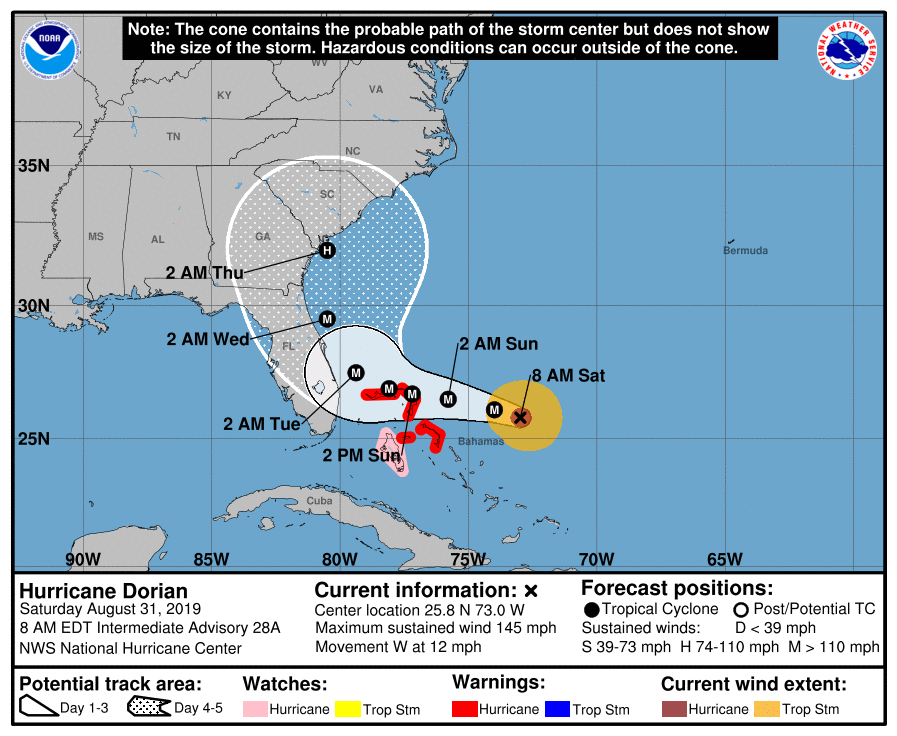
Dorian is now a major, category 4 hurricane heading west at 12 miles per hour. It is currently 655 miles southeast of Chatham County. The storm has sped up since yesterday, but is anticipated to continue to slow down significantly over the next several days. The track shift overnight has the storm turning earlier than previously anticipated and models are less confident in a Florida landfall. Chatham County remains in the storm’s error cone mid to late next week and we could see direct impacts in our area.
Now is the time to take preparedness actions. Set aside some time this weekend to prepare for the potential of coastal flooding, heavy rain, and strong winds. Preparedness items could include securing loose items outside your home that could become air-borne, taking an inventory of important items in your home in case you need to file an insurance claim, and updating your family emergency kit. For a list of other things you can do to prepare, visit www.chathamemergency.org.
CEMA is actively monitoring the storm and will be in the Emergency Operations Center this weekend. We will provide updates as necessary to keep you informed. For the most up to date information, be sure to visit our social media pages @ChathamEMA. If you have any questions about the storm or the County’s plans, don’t hesitate to call us at 912-201-4500.
Agosto 31, 2019 a las 8:00 AM Dorian es un Huracán Mayor Categoría 4 moviéndose hacia el oeste a 12 millas por hora. Actualmente Dorian se encuentra a 655 millas al sureste del Condado Chatham. La tormenta acelero su curso desde ayer, pero se pronostica que continúe desacelerando su curso a lo largo de los próximos días. El cambio de rumbo desde anoche pareciera indicar un cambio de rumbo antes de lo anticipado y los modelos ya no están tan seguros del impacto a la Florida. El Condado de Chatham continua dentro del cono de error hasta por lo menos mediados de la semana que viene y pudiera impactarnos directamente.
Este es el momento de hacer preparativos. Tómese el tiempo este fin de semana para prepararse para estas eventualidades - fuertes vientos, inundaciones, y lluvias torrenciales. La preparación podría incluir asegurar artículos (sillas, mesas, paraguas) que están sueltos en su jardín y que pudiesen salir volando abastecer su alacena de comida no perecedera, agua, hacer una lista de objetos y pertenencias en su hogar si tuviese que hacer un reclamo al seguro, y actualizar su plan de emergencia familiar. Para una lista mas detallada de los preparativos visite nuestra pagina de web www.chathamemergency.org.
CEMA continuara monitoreando la tormenta durante todo el fin de semana y la semana que viene. Continuaremos actualizando la información según sea necesario. Para la información más actualizada asegúrese de visitar nuestra página social o nuestra página de web www.chathamemergency.org. Si tiene alguna pregunta sobre la tormenta o desea información de como prepararse no deje de comunicarse con nosotros al 912-201-4500
Hurricane Dorian 08/30/2019 - 5 PM Update
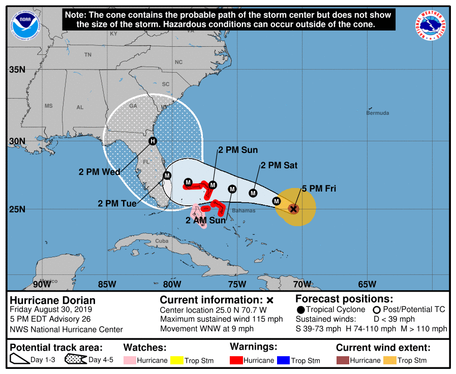
Dorian is now a major, category 3 hurricane heading west-northwest at 9 miles per hour. It is currently 789 miles southeast of Chatham County. The storm has slowed down again since this morning and is anticipated to continue to slow down significantly over the next several days. The track suggests landfall in Florida Tuesday. However, Chatham County remains in the storm’s error cone mid to late next week. This means that we could see potential impacts of heavy rain, strong winds, and coastal flooding through the end of next week.
Take the time this weekend to prepare for the potential of coastal flooding, heavy rain, and strong winds. Preparedness items could include stocking your pantry with non-perishable food items and water, taking an inventory of important items in your home in case you need to file an insurance claim, and updating your family emergency plan. For a list of other things you can do to prepare, visit www.chathamemergency.org.
CEMA will monitor the storm throughout the weekend and into next week. We will provide updates as necessary to keep you informed. For the most up to date information, be sure to visit our social media pages @ChathamEMA. If you have any questions about the storm or the County’s plans, don’t hesitate to call us at 912-201-4500.
En este momento Dorian es un Huracán Mayor de Categoria 3 con rumbo oeste-noroeste a 9 millas por hora. Actualmente se encuentra a 789 millas de Chatham County. La tormenta ha disminuido su velocidad de nuevo y se espera que continue disminuyendo su velocidad considerablemente durante los próximos días. La trayectoria parece indicar que impactara a Florida el martes. Sin embargo, Chatham County continua dentro del cono de error hasta finales de la semana que viene. Eso significa que pudiésemos observar fuertes lluvias, fuertes vientos, e inundaciones a nivel de la costa toda la semana que viene.
Tomese el tiempo este fin de semana para prepararse para estas eventualidades - fuertes vientos, inundaciones, y lluvias torrenciales. La preparación podría incluir abastecer su alacena de comida no perecedera, agua, hacer una lista de objetos y pertenencias en su hogar si tuviese que hacer un reclamo al seguro, y actualizar su plan de emergencia familiar. Para una lista mas detallada de los preparativos visite nuestra pagina de web www.chathamemergency.org.
CEMA continuara monitoreando la tormenta durante todo el fin de semana y la semana que viene. Continuaremos actualizando la información según sea necesario. Para la información más actualizada asegúrese de visitar nuestra página social o nuestra página de web www.chathamemergency.org. Si tiene alguna pregunta sobre la tormenta o desea información de como prepararse no deje de cominicarse con nosotros al 912-201-4500
Hurricane Dorian 08/30/2019 - 11 AM Update
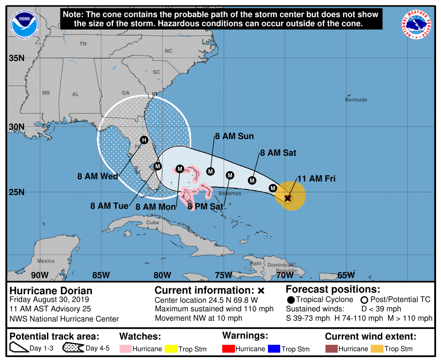
Dorian is currently 852 miles southeast of Chatham County and is heading northwest at 10 miles per hour. The storm has slowed down again since this morning and is anticipated to continue to slow down significantly over the next several days. The track still suggests landfall in Florida between Monday and Tuesday. However, Chatham County is now included in the storm’s error cone mid to late next week. This means that we could see potential impacts of heavy rain, strong winds and coastal flooding through the end of next week.
Residents are encouraged to prepare for these potential impacts from Dorian. Ensure you have your emergency kit stocked and ready to go and it includes non-perishable food and water for 3-5 days. Also, be sure to re-fill your prescription medications if you are low to ensure you have plenty to get through next week.
CEMA will monitor the storm throughout the weekend and into next week. We will provide updates when necessary to keep you informed. For the most up to date information, be sure to visit our social media pages or our website www.chathamemergency.org. If you have any questions about the storm or how you can prepare, don’t hesitate to call us as well at 912-201-4500.
Dorian se encuentra a 852 millas al suroeste de Chatham, y se dirige al noroeste a 10 millas por hora. La tormenta desacelero su curso nuevamente esta mañana y se espera que continúe desacelerando su trayectoria durante los próximos días. Según el curso actual se espera que haga impacto en Florida entre lunes y martes. Sin embargo, el condado de Chatham se encuentra en estos momentos dentro del cono de error a partir de mediados de la semana que viene. Esto significa que podríamos ver fuertes lluvias, fuertes vientos, y inundaciones costeras hasta el final de la semana que viene.
Se les recomienda encarecidamente a los residentes del condado que tomen las precauciones necesarias para esta eventualidad. Asegúrese de tener a la mano su kit de emergencia que incluya comida no perecedera y agua para 3 a 5 días. Así mismo, asegúrese de tener suficiente medicina y rellenar su receta si es necesario a fin de tener suficiente para toda la semana que viene.
CEMA continuara monitoreando la tormenta durante todo el fin de semana y la semana que viene. Continuaremos actualizando la información según sea necesario. Para la información más actualizada asegúrese de visitar nuestra página social o nuestra página de web www.chathamemergency.org. Si tiene alguna pregunta sobre la tormenta o desea información de como prepararse no deje de cominicarse con nosotros al 912-201-4500
Hurricane Dorian 08/30/2019 - 8 AM Update
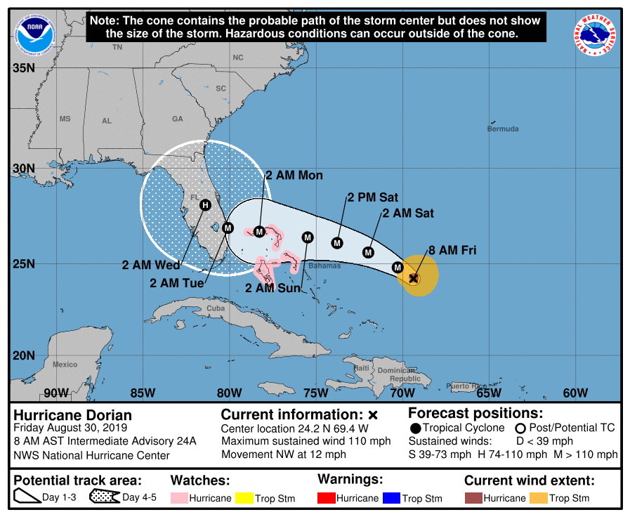
Dorian is currently 929 miles southeast of Chatham County and is heading northwest at 12 miles per hour. The storm has slowed down again and is anticipated to continue to slow down over the next several days. The track has shifted south again, but the error cone is now showing that by mid to late next week, it could be heading towards Southeast Georgia.
Heavy rainfall and coastal flooding are still possible as early as this weekend. Low-lying areas and roadways could flood, especially during the evening high tides. Residents should prepare for potential impacts from Dorian into next week as the storm makes landfall and moves north.
CEMA will monitor the storm throughout the weekend and provides updates as needed. If you have any questions about the storm or how you can prepare, don’t hesitate to contact us.
Hurricane Dorian 08/29/2019 - 5 PM Update
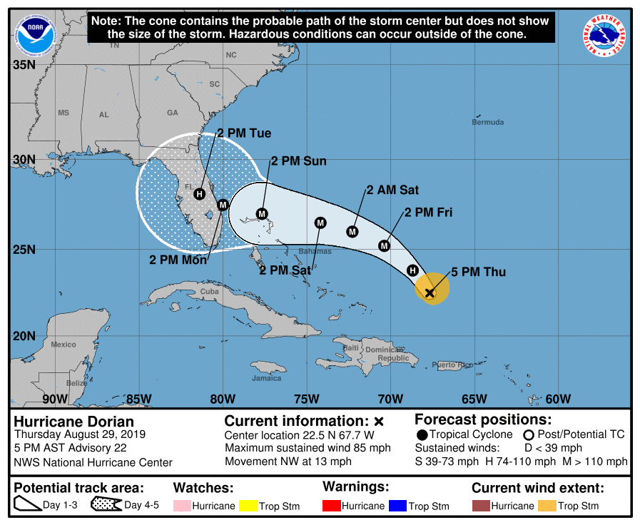
Hurricane Dorian is currently 1,055 miles southeast of Chatham County and is moving northwest at 13 miles per hour. The forecast track has remained consistent throughout the day and Chatham is still outside of the error cone. As mentioned earlier, impacts are possible in Chatham County including potential heavy rainfall and coastal flooding. There is a coastal flooding warning in effect until midnight tonight.
Governor Kemp has issued a State of Emergency for 12 Georgia Counties, including Chatham. The State of Emergency will assist with preparation, response, and recovery activities for Hurricane Dorian. The order also puts into effect price gouging regulations. In addition, Governor Kemp issued a second Executive Order to help ensure uninterrupted gas and supply delivery throughout the state and allows for extended hours and distance of deliveries.
CEMA will continue to monitor Hurricane Dorian and any impacts it may bring to our community. Let us know if you have any questions or concerns!
Hurricane Dorian 08/29/2019 - 11 AM Update
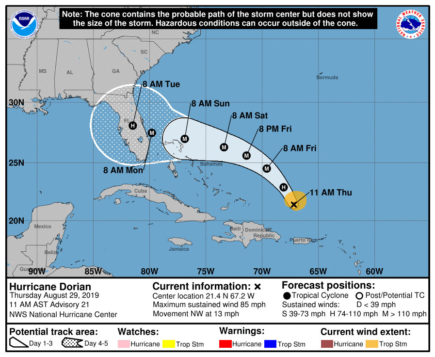
Hurricane Dorian’s path has remained consistent for the 11am advisory and Chatham County remains outside of the error cone. Dorian is currently 1,192 miles southeast of Savannah and is traveling northwest at 13 miles per hour.
While Chatham remains outside of the error cone, remember, impacts are still possible. According to the National Weather Service, there is a potential for heavy rain and coastal flooding throughout the weekend and early next week in our area. Continue to monitor this storm as it moves northwest towards the United States coastline as the track could shift north again.
For the most up to date information, be sure to follow CEMA on social media or visit our website at www.chathamemergency.org. Or, feel free to contact our office with questions at 912-201-4500; we are here to help!
Hurricane Dorian 08/29/2019 - 5 AM Update
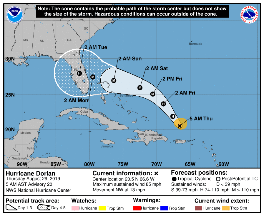
Hurricane Dorian is currently 1,120 miles southeast of Savannah and is moving toward the northwest near 13 mph. The track has shifted south again and Chatham County remains outside the error cone. Although the county is outside of this cone, that does not mean we are out of the woods yet. The track is still incredibly uncertain. In addition, the cone only depicts the path for the eye, or center, of the storm. Impacts can and often do appear outside of the cone itself.
CEMA is continuing to monitor the storm and any effects it may bring to the county. Please continue to watch this storm as the track could change. For up to date information, follow CEMA on social media or visit our website: www.chathamemergency.org
Hurricane Dorian 08/28/2019 - 5 PM Update
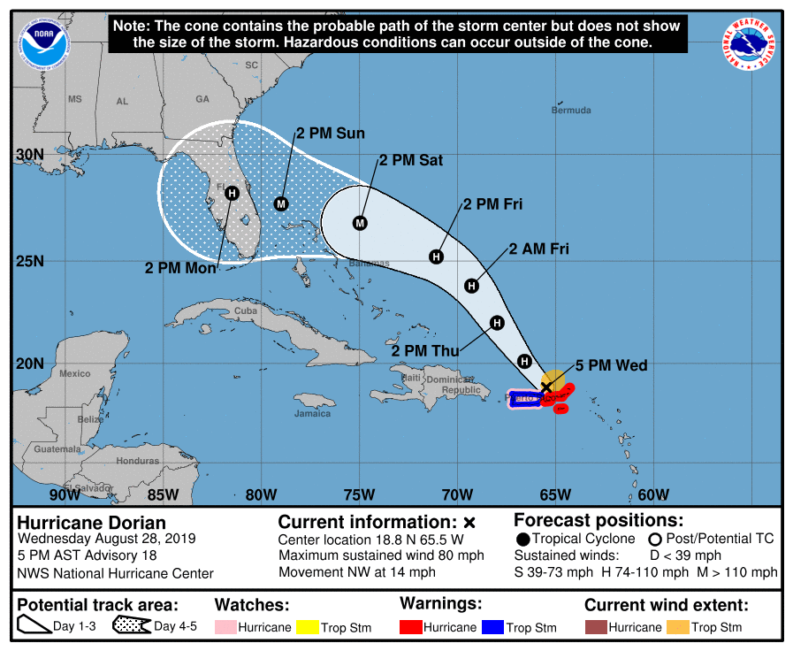
Dorian was upgraded to a hurricane earlier today and is projected to stay at hurricane strength for the next few days before upgrading to a major hurricane (category 3) later this week/weekend. Dorian is currently 1,287 miles away from Savannah.
The track has shifted slightly south and Chatham County is no longer in the error cone or the cone of uncertainty. However, this does not mean that Chatham County will not see any impacts. CEMA will continue to monitor the storm.
As always, if you have any questions or concerns about the storm or how CEMA is preparing, please don’t hesitate to contact us. For up to date information, be sure to follow us on social media or continue watching our website.
Tropical Storm Dorian 08/28/2019 - 11 AM Update
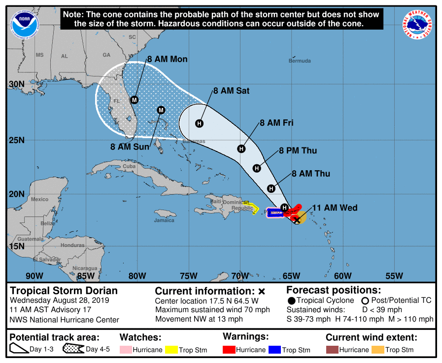
TS Dorian is moving toward the North West and is expected to become a hurricane later today. It’s currently 1,392 miles SE of Savannah. At this time, it is still too early to say what impacts Dorian may bring to Chatham County. However, CEMA will continue to monitor the storm.
It is time for you to do your part! Is your emergency kit ready to go? Are you, and your family, prepared? Take the time now to prepare.
For up to date information and preparedness tips, be sure to follow CEMA on social media. If you have any specific questions, don’t hesitate to contact our office at 912-201-4500.
CEMA Enters the Enhanced Monitoring Phase (Operating Condition 4) for Tropical Storm Dorian
Chatham County, GA (August 28, 2019) - At 8 am this morning, the Chatham Emergency Management Agency (CEMA) entered the Enhanced Monitoring Phase (OPCON 4) as Tropical Storm Dorian approaches the east coast of the United States. Everyone in Chatham County should review their personal emergency plans at this time to be prepared for any impacts to our area.
As a common practice, individuals, families, and businesses are encouraged to review their storm preparation activities:
- Monitor local authorities for advice and protective actions.
- Prepare or inspect your emergency supply kit, and do not forget your pet’s kit too.
- Create or update your family evacuation plan, detailing how and where you will evacuate and where you could meet if separated.
- Document important belongings and consider taking pictures or video of your home.
- Inspect your property for loose, lightweight items that could become airborne.
- If you have functional access or medical needs call the Chatham County Public Health Department to sign up for the registry, 1-833-CHD-REGISTER
CEMA’s Enhanced Monitoring Phase activities will include:
- Monitoring the storm with each advisory
- Sending regular updates via social media and posting relevant information on CEMA’s Website.
CEMA Enters the Enhanced Monitoring Phase (Operating Condition 4) for Hurricane Dorian
Chatham County, GA (August 28, 2019) - At 8 am this morning, the Chatham Emergency Management Agency (CEMA) entered the Enhanced Monitoring Phase (OPCON 4) as Hurricane Dorian approaches the east coast of the United States. Everyone in Chatham County should review their personal emergency plans at this time to be prepared for any impacts to our area.
As a common practice, individuals, families, and businesses are encouraged to review their storm preparation activities:
- Monitor local authorities for advice and protective actions.
- Prepare or inspect your emergency supply kit, and do not forget your pet’s kit too.
- Create or update your family evacuation plan, detailing how and where you will evacuate and where you could meet if separated.
- Document important belongings and consider taking pictures or video of your home.
- Inspect your property for loose, lightweight items that could become airborne.
- If you have functional access or medical needs call the Chatham County Public Health Department to sign up for the registry, 1-833-CHD-REGISTER
CEMA’s Enhanced Monitoring Phase activities will include:
- Monitoring the storm with each advisory
- Sending regular updates via social media and posting relevant information on CEMA’s Website.